Methods For Direction Finding Without Compass Or GPS
In some survival or disaster situations it is imperative that you are able to travel overland instead of waiting it out at a fixed point (house, camp, car, etc). Although, GPS units are becoming cheaper and more common every year, its good to have a backup plan for when devices fail, batteries die or gear is lost. The following are several tried and true methods using the simplest of techniques and equipment to orient yourself. Please take note of the geographical limitations of some of these methods in one hemisphere or the other or if you are very close to the Equator.
Notes About The Sun’s Movement
The sun’s position north or south of the equator is called declination. It is furthest north on
June 21, crosses the equator on September 21, is farthest south on December 21 and recrosses the equator on it’s way north on March 21. Any east–west line indicated when the sun crosses the equator on the 21 March and the 21 September will be accurate.
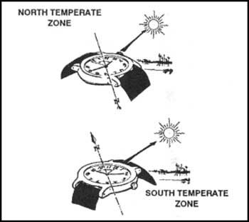
The Watch Method of OrienteeringStand holding your wristwatch horizontal with the figure 12 pointing at the sun Bisect the angle between the hour hand and the 12 O’clock position (The reason you need to cut it in two, is because the clock takes two rotations while the sun takes one around the earth, it is of course the other way around, but never mind.). The line will indicate South if you are in the Northern Hemisphere and North if you are in the Southern Hemisphere. This method can be used even if you do not have a watch if you can construct your own dial in the dirty or on paper. |
Hand-Span Method of Determining North/South
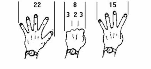
The sun crosses the imaginary north/south line [meridian] every day at noon and there are 24 hours between crossings of the meridian. During this time the earth revolves through 360°. It can therefore be said the sun travels from east to west at a speed of 15° per hour. To find north simply note the time and plot the sun from its present position backward or forward as the case may be to its noon position. The diagram below will give you a general indication of measuring degrees using your hand span. You can experiment with this method and increase accuracy by measuring sun movement with your hand and then measuring it with a compass for comparison.
 |
Additional Research:
  |



Leave a Reply